Supportive Initiatives
Over the past two years the DPW and FHWA have partnered on a number of initiatives to augment and support the 2030 Guam Transportation Program. These supportive initiatives, consistent with the Stewardship Agreement, are designed to bring the DPW into compliance with federal requirements, stabilize processes within the DPW Division of Highways, provide additional programmatic planning tools and standardize engineering and construction planning, design and implementation for federally funded road projects. These supportive initiatives include, but are not limited to:
Village Streets Master Plan (VSMP)
The VSMP was developed to provide a comprehensive assessment of roadway improvements needed at the village level with a structure for implementation. Focusing on arterials, collector and local roads, the plan generally excludes federal-aid routed road projects identified in the 2030 GTP. The development of the plan included extensive collaboration with all mayors establishing a process for prioritization of road and safety improvements as well as the elimination of project overlaps created by Public Law 26-68. The Bureau of Statistics and Plans are presently reviewing the plan for formalized adoption by the Government of Guam.
Storm Water Master Plan (SWMP)
As a companion document to the Village Streets Master Plan, the SWMP focuses on storm water drainage issues and recommendations associated with existing village arterials, collector and local roads. The plan was developed cooperatively with the Guam Environmental Protection Agency, WERI, BSP, the Army Corps of Engineers and a number of other local and federal agencies. The final draft plan is going through its final review by participating agencies and will be submitted to the Office of the governor for formalized adoption in the first quarter of 2011.
Transportation Storm Drainage Manual (TSDM)
The TSDM was developed to supplement the Guam Environmental Protection Agencies (GEPA) drainage manual and guidelines. The GEPA manual does not have adequate provisions for transportation (long, linear) projects, so the TSDM was developed to supplement the manual in addressing storm water quality, detention, treatment requirements, better management practices. The TSDM provides design guidance to properly design storm water drainage features in compliance with GEPA and USEPA water quality standards.
Guam Road Network Implementation Plan (for storm water drainage)
The Guam Road Network Implementation Plan (GRNIP) was developed in coordination with the final EIS for the military build-up. Its primary focus was to develop a concept for storm water drainage facilities that may be required to meet hydraulic and environmental requirements for the military haul road network projects. As individual GRN projects move from concept into design, the manual provides guidance for selecting storm water drainage and water quality features that will meet the requirements of jurisdictional permitting agencies (Guam EPA, US EPA and the Army Corps of Engineers (ACOE). The GRNIP was developed in cooperation with: FHWA, US EPA, Guam EPA, ACOE, Bureau of Statistics and Plans and the Guam Attorney General’s office. Each of these agencies participated in task force meetings to develop and review the GRNIP.
Right of Way (ROW) Manual
The ROW Manual was developed to formalize the process, policies and procedures for determining and acquiring Right’s of Way for the various road improvement projects included in the Territorial Transportation Improvement Program and the Guam Road Network. The manual provides prescriptive polices and detailed procedures for the acquisition of Rights of Way to include property owner rights, partnering agencies and legal processes. The manual also ensures that all Rights of Way acquisition processes are compliant with FHWA regulations and Guam laws. This allows for federal funds to be utilized for acquisition when necessary for the various projects along routed roads. Development of the manual included a series of public meetings to explain its purpose and to obtain public comments.
Guam Transportation Training Initiative (GTTP)
In September of 2009, the DPW applied for and was granted $1.5 million in American Reinvestment and Recovery Act (ARRA) Funds through the FHWA. The grant program was specifically designed to provide On The Job Training and Supportive Services for Guam’s underserved population that face barriers to employment. The grant is presently split into two separate categories. $900k has been allocated for the Guam Transportation Training Initiative that focuses on training local underserved residents and $600k has been allocated to support training programs for residents of the FSM looking for employment on Guam. In partnership with the Guam Trades Academy, the Guam Community College, and other service providers, the GTTP presently services over 200 applicants who are receiving training in transportation related jobs and careers. Once their training is complete, the individuals will be placed in local construction companies for On-The-Job training and eventual permanent placement. The FSM training program is expected to launch this year.
Transit Business Plan, 2009 - 2015
The Transit Business Plan sets out the background, opportunities, and proposed improvement plan for the Guam Regional Transit Authority (GRTA). The Plan includes anticipated ridership, service plans, capital and operating requirements, and a draft financial plan.
Standard Plans and Details
Over 100 Standard Plans have been prepared for repetitive construction details on road and bridge projects. To complement the plans and provide for future additions and modifications, Standard Procedures for the development, approval, and use of Standard Plans and Details were developed and coordinated with the Professional Engineers, Architects, and Land Surveyors (PEALS) Board.
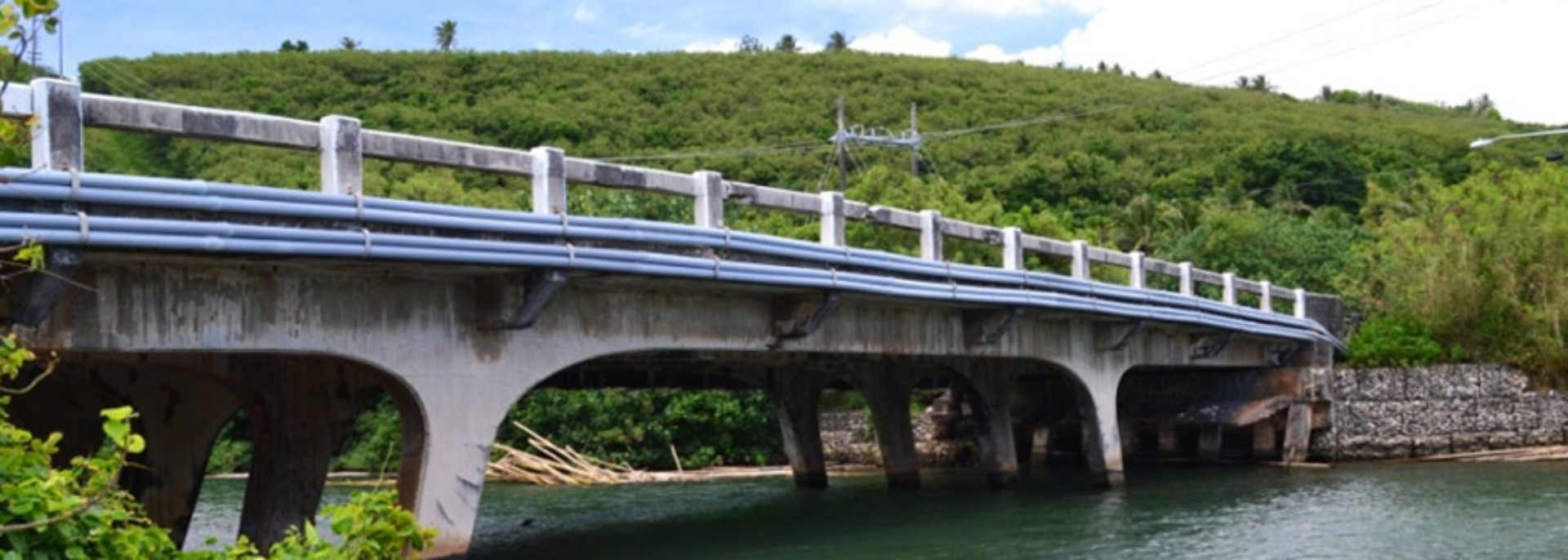
Bridge Inspection and Rating Program
Condition inspections and load rating analyses were performed on thirty-four (34) Guam highway bridges. Reports on each individual bridge include results of the systematic inspections, drawings documenting the dimensions and location of structural members, photos, and the results of the load rating analysis. The load rating analysis included comparison of the bridges current capacity to Guam’s maximum load limits and also loads that may be imposed by heavy military vehicles.
Results of the analysis were used to identify substandard bridges for repair, strengthening, or replacement, both for Guam Legal Loads and for the heavier vehicles proposed by the U. S. Military. Several bridges are currently being rehabilitated and replaced, with others to be programmed in future years.
Environmental Procedures Guide
Currently in draft form, the Environmental Procedures Guide was created to assist the Department of Public Works and its design consultants in compliance with environmental regulations. The Guide identifies the current best practices for preparing and processing documents, conducting agency coordination and review, and conducting public involvement where appropriate. The Guide is comprised of twenty (20) modules, each addressing the procedures for compliance with national and local environmental laws. These laws include the National Environmental Policy Act (NEPA), the Endangered Species Act, Section 106 of the National Historic Preservation Act, Coastal Zone Management Consistency Determination, etc.
Potential Funding Sources for Guam’s Long Term Transportation Needs
This report provides a review of potential revenue sources to meet the unfunded needs of the 2030 Guam Transportation Plan. It identifies the revenues currently in use in Guam, examines revenue sources in other territories and states, and provides a list of potential new or incremental revenue sources. These potential revenue sources include incremental increases to the gross receipts tax, liquid fuel tax, and hotel occupancy tax; and new revenue sources including vehicle license fees, motor vehicle rental fees, and tour vehicle surcharge.
Traffic Signal Timing and Coordination Program
Following an initial evaluation of traffic signal operations on Guam’s major corridors, a traffic signal timing and coordination program was initiated to improve traffic flow by reducing delay at intersections. Measurable benefits include reduced travel time, decreased fuel consumption and reduced harmful vehicle emissions. A report on before-and-after travel times on Route 1 (Marine Corps Drive) between Route 2A (at Naval Base Main Gate) and Route 29 (Gayinero Road) indicated travel benefits were realized in all peak periods. The most significant benefit occurred in the northbound direction during the off-peak period that experienced an approximate 24 percent reduction in travel time. This 19-mile corridor includes traffic signals at 33 intersections.
Program Management Information System
A Program Management Information System (PMIS) has been developed that integrates six commercial programs for document control, scheduling, construction management, cost control, estimating and risk management. Managers can gain access to either summary or detailed information through an internet-based “dashboard”.
Construction Management Program
The goal of the Construction Management (CM) program is to bring DPW into federal compliance on all federally funded projects, protecting GovGuam’s critical federal funds and to prepare DPW for the impending build-up projects. The scope of the CM program includes; development of a construction manual, operational policies and procedures, document control systems (electronic and hard copy), audit procedures and training DPW inspectors and office engineers. The program also involves the development and implementation of non-PMT construction management services program, whereby engineering consultants (outside of the PMT) are contracted with DPW to perform CM services on federally funded projects. A critical element of the CM program is to consistently ensure federal compliance at all levels during construction for all projects.
Construction Management and Inspection Services (CMIS) Manual
A CMIS manual has been developed detailing construction management policies and procedures for compliance with FHWA requirements. The manual provides detailed information on inspection, quality control, quantity calculations, material testing, documentation, payment processing, audit procedures and other aspects of operating and maintaining a federally compliant construction program. A training program was developed for all active DPW inspectors and office engineers have been trained and tested on the key elements of the program. DPW staff training is on-going, with the consultants providing advice and staff augmentation for active construction projects.
Americans with Disabilities Act Compliance Monitoring
An assessment of all the existing sidewalks along Federal Highway routes for compliance with the Americans with Disabilities Act Access Guidelines (ADAAG) is currently underway. The data gathered from this assessment will assist the DPW in fulfilling the terms of the Settlement Agreement under Civil Case No. CV01-00047 related to improving access along pedestrian rights-of-way on Guam. A report will be prepared documenting the locations and types of all barriers to access such as non-compliant curb ramps, crosswalk access, slopes, and obstacles within the sidewalks. The report will provide the basis for planning and implementing corrective action.
Asset Management Information System (AMIS)
As a supportive initiative to the Rights of Way verification process for road planning and design, an Asset Management Information System was developed to provide access to property records and government asset information for designers and planners. Working with the Department of Land Management, the Bureau of Statistics and Plans, and other GovGuam agencies, the DPW and its consultants designed and created a an application that provides easy access to DLM land records to include property maps and historical deed and conveyance documents. All recorded maps were converted into a parcel-planning layer that includes roads, utilities, topography and LIDAR imagery. The AMIS includes visual motion and ground mounted LIDAR imagery of all routed roads that is web-based for more efficient, effective and accurate information sharing among agency planners.
File an Americans with Disabilities Act (ADA) Report
Office of the Governor of Guam


Meet our Leaders